
Uganda / Mgahinga Gorilla / Zones — Mgahinga Gorilla
Zones — Mgahinga Gorilla
Thirty-three point seven square kilometres with one gate, one visitor centre and seven named trails — this is the only Ugandan gorilla park where the word sector does not apply, and that is the whole story of how it is used.
Ntebeko — one gate, one trailhead, everything starts here
Bwindi has four sectors and choosing the wrong one is an expensive mistake. Mgahinga has Ntebeko. UWA's brochure puts it plainly: the Visitor Centre at Ntebeko is the trailhead for nature walks, volcano climbs, and golden monkey and gorilla tracking. Every activity this park sells begins at the same building, and gorilla tracking begins there at 08:00 daily.
Ntebeko at a glance
| Altitude | 2,227 m — the low point of the park's range |
| Gorilla tracking start | 08:00 daily, at the visitor centre |
| Typical gorilla trek | 3 to 5 hours, per UWA's brochure |
| Distance from Kisoro town | 14 km, by a rough road with steep rocky sections |
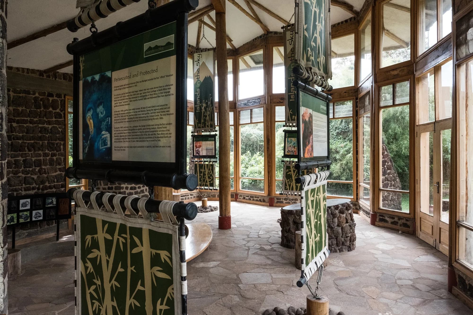
| What is inside | Exhibits on the Virunga environment |
| Gate hours | UWA's park rules: gates open between 7am and 7pm |
Altitude, start time, trek length and the 14 km are from UWA's Mgahinga brochure; the 2,227 m figure is corroborated on UWA's own park page, which gives the park's range as 2,227 m to 4,127 m. The gate hours are the general rule printed on the tariff's park rules page and are not specific to Mgahinga.
The one thing a single trailhead changes about your planning
At Bwindi the question is which sector, and the answer determines which lodge, which road and which three-hour transfer. At Mgahinga there is no such question, which removes the single most expensive booking error in Ugandan gorilla tourism — UWA's fines table prices tracking in a different location at 50 per cent of the permit fee, and the usual way people incur it is by sleeping in the wrong Bwindi sector. You cannot make that mistake here. The corresponding Mgahinga mistake is a different one and it is on the sightings page.
How big is this park, exactly — and is it really Uganda's smallest
Thirty-three point seven square kilometres is the figure, and it is unusually well attested: UWA's website, UWA's brochure, UWA's General Management Plan, UWA and the Ministry of Water and Environment's 2023 plan, the Greater Virunga Transboundary Collaboration and a 2023 paper in Proceedings of the Royal Society B all print 33.7 km². Two authorities disagree. The World Database on Protected Areas, maintained by UNEP-WCMC, gives Mgahinga a reported area of 38.0 km² under site ID 313109. And Uganda's own National Forestry Authority manages to print three different figures on one page — 34 sq kms in its text, 33.7 sq km a paragraph later, and 38.6 sq Km in its quick-facts box. We publish 33.7 km² as UWA's own figure, note that a WDPA reported area is what a state reported to UNEP-WCMC rather than necessarily the park authority's current number, and flag the NFA page as internally inconsistent rather than as a source. On Uganda's smallest national park: UWA states it in those words on its own website and in its own brochure, and no other Ugandan park claims the title. Lake Mburo claims the smallest savanna park in Uganda, which is a different scope and a different crown; both claims stand together.
Running along the edge of the park beside the visitor centre is the Buffalo Wall, a drystone wall built to keep animals out of neighbouring farmland. UWA's brochure recommends the trail along it for birding and for views of the volcanic backdrop, and it is the one piece of this park you can walk on a USD 40 entrance ticket without buying an activity. It is also the clearest thing at Mgahinga to look at if you want to understand the park's actual problem: on one side is forest, on the other side Bafumbira farmers cultivate up to the boundary, and the wall is the whole of the space between them.
Uganda Wildlife Authority — Mgahinga Gorilla National Park brochure, 2018
UWA's own two-page park brochure, linked from the download button on its Mgahinga page and hosted on ugandawildlife.org. The file's internal creation date is 19 June 2018 and it is still the brochure UWA publishes. Downloaded and read 14 October 2026. It is the only UWA document that gives the heights of the three volcanoes, the names and their meanings, the 524 km road distance, the 80 km Kabale–Kisoro leg, the 14 km climb to Ntebeko, the 08:00 tracking start, the climate figures, the Garama cave description and the twenty per cent revenue share. It disagrees with UWA's own park page on the bird count and gives two different distances for Lake Mutanda. Both are published here.
https://ugandawildlife.org/wp-content/uploads/2024/05/MGNP-2018-4.pdfUganda Wildlife Authority — Mgahinga Gorilla National Park
UWA's own Mgahinga park page, read 14 October 2026. The source here for the park size of 33.7 square kilometres, the altitude band of 2,227 m to 4,127 m, the 1930 game sanctuary and 1991 national park dates, the meaning of the name, the mammal and bird counts, the single habituated transboundary gorilla group, the nine-hour road time from Kampala and the Kisoro airstrip flight time. It prints an entrance figure for foreign non-residents, foreign residents and East Africans and no rest-of-Africa figure at all.
https://ugandawildlife.org/national-parks/mgahinga-gorilla-national-park/Uganda Wildlife Authority — Mgahinga Gorilla National Park General Management Plan 2014–2024
UWA's own ten-year management plan for this park, hosted on ugandawildlife.org and read 14 October 2026. It is not linked from UWA's Mgahinga page and it does not appear in UWA's site search, because that search does not index PDFs — it returns zero results for the word habituation, which appears repeatedly in UWA's own tariff. This is the document that names the habituated gorilla group, states its size, describes its ranging across two international borders, records that UWA loses revenue when it crosses, and states that golden monkeys are found only here in Uganda. It is also internally inconsistent on Sabinyo's height, Gahinga's height and the park's lower altitude, and we publish those inconsistencies rather than choosing between them.
https://ugandawildlife.org/wp-content/uploads/2022/01/Mgahinga_Gorilla_National_Park_GMP_2014-2023.pdfUNEP-WCMC — World Database on Protected Areas, Mgahinga Gorilla, site ID 313109
Protected Planet's record for this park, read 14 October 2026, citing UNEP-WCMC (2026), Protected Area Profile for Mgahinga Gorilla from the World Database on Protected Areas, October 2026. Cited here only for the reported area of 38.0 km², which disagrees with every UWA figure. We could not retrieve the GIS-calculated area to compare: the detail endpoint returned HTTP 500 and the API requires a token. We also could not read UNESCO's tentative-list entry for Mgahinga, number 5099, because whc.unesco.org returned HTTP 403 behind Cloudflare to every attempt.
https://www.protectedplanet.net/313109Uganda Wildlife Authority — Conservation Tariff 2024–2026
Read page by page on 14 October 2026. The 24-page tariff, covering entrance, vehicles, aircraft, walks, primate permits, the Batwa Trail, mountain activities, camping, UWA accommodation, research fees, fines and a per-park fees summary. Mgahinga appears in nine separate places in it — the Category A entrance band, the gorilla table headed for Bwindi and Mgahinga together, the golden monkey table, the walks table, the Batwa Trail table, the mountain activities table, the accommodation block, the fines table and its own one-page summary on document page 20 — and those nine places do not always agree. The tariff is printed "subject to change without prior notice" and its cover period, July 2024 to June 2026, expired on 30 June 2026 without a successor appearing on UWA's site.
https://ugandawildlife.org/wp-content/uploads/2024/03/UWA-Conservation-Tariff-July-2024-June-2026.pdfThe three volcanoes, and what each is actually like
The park is the Ugandan slopes of three of the Virunga chain's six volcanic summits. UWA's brochure gives each a height, a name meaning and a character, and the three are genuinely different climbs rather than three versions of one. All three, UWA says, can be climbed in a day.
The three volcanoes, from UWA's own brochure
| Volcano | Height | Name means | What is at the top |
|---|---|---|---|
| Muhavura | 4,127 m | The guide | A crystal clear crater lake, 40 m in diameter, and panoramic views along the whole Virunga chain |
| Sabinyo | 3,669 m | Old man's teeth | A jagged crown of several summits divided by deep gorges and ravines; you stand in three countries at once |
| Gahinga | 3,474 m | Small pile of stones | A lush swamp-filled crater about 180 m wide, on bamboo-covered slopes |
Heights as UWA's brochure gives them; Sabinyo's is disputed and the next table sets out by whom. Gahinga is described as the smallest of all the Virunga volcanoes, not merely the smallest of these three, and it is the volcano that gives the park its name — gahinga is the local word for the piles of volcanic stones farmers clear from the fields at the foot of the range.
Sabinyo's height — four authorities, four numbers
| Height | Source | Spelling used |
|---|---|---|
| 3,669 m | UWA Mgahinga brochure, 2018 | Sabinyo |
| 3,669 m | Greater Virunga Transboundary Collaboration | Sabinyo |
| 3,645 m | UWA General Management Plan 2014–2024 | Sabinyo and Sabyinyo, both |
| 3,645 m | UWA / Ministry of Water and Environment, March 2023 | Sabyinyo |
| 3,637 m | Ayebare et al. 2023, Proceedings of the Royal Society B | Sabinyo |
| 3,534 m | Roy et al. 2014, BMC Ecology | Sabyinyo |
A hundred and thirty-five metres between the highest and lowest figure, and the Uganda Wildlife Authority is on both sides of it — 3,669 m in the brochure it hands tourists, 3,645 m in the management plan it runs the park by. We are not resolving it. If you want the number for the summit certificate, it is UWA's 3,669 m, which is also the figure UWA uses when it sells you the three-countries-at-once line.
Muhavura, Muhabura, Muhuvura — and which spelling the authorities use
The height is not in dispute: 4,127 m, agreed by UWA's brochure, UWA's management plan, the Greater Virunga Transboundary Collaboration and two peer-reviewed papers. The spelling is. UWA's brochure writes the mountain as both Muhuvura and Muhavura on the same two pages. UWA's management plan writes it as both Muhabura, dominantly, and Muhavura. GVTC and both peer-reviewed papers use Muhabura. So Muhuvura — the spelling in UWA's tourist brochure and in its own map key — is the outlier, and Muhabura is what the scientific and transboundary literature uses. We write Muhavura in the running text because it is the form UWA uses in the sentence that gives the height, and we are telling you about the other two rather than silently picking one. Gahinga is given as 3,474 m by the brochure, the management plan and both papers — though the plan also prints 3,473 once, in its own tourism chapter, in the same sentence where it prints Sabinyo at 3,669.
Sabinyo has a ladder, and the brochure does not bury it
UWA's own description of the Sabinyo climb: some steep and vertiginous sections, including an ascent of a fixed ladder, must be negotiated to reach the summit. That is a park authority writing its own promotional brochure and still using the word vertiginous. If you are uncertain about exposure, the Sabinyo summit is the one to think hard about; the Sabyinyo gorge walk at the foot of the same mountain is a different activity entirely and costs USD 30.
Muhavura is the one with the ecological claim attached. UWA's brochure says it is the only mountain in south-west Uganda to display the full range of altitudinal vegetation zones peculiar to East Africa's highest mountains, and describes the ascent passing through montane forest, then bamboo, then heather groves, and finally the giant lobelias and groundsels of the Afro-alpine zone before the crater lake at 4,127 m. If you have climbed the Rwenzori or Mount Elgon and want the compressed version in a single day, this is it.
Uganda Wildlife Authority — Mgahinga Gorilla National Park brochure, 2018
UWA's own two-page park brochure, linked from the download button on its Mgahinga page and hosted on ugandawildlife.org. The file's internal creation date is 19 June 2018 and it is still the brochure UWA publishes. Downloaded and read 14 October 2026. It is the only UWA document that gives the heights of the three volcanoes, the names and their meanings, the 524 km road distance, the 80 km Kabale–Kisoro leg, the 14 km climb to Ntebeko, the 08:00 tracking start, the climate figures, the Garama cave description and the twenty per cent revenue share. It disagrees with UWA's own park page on the bird count and gives two different distances for Lake Mutanda. Both are published here.
https://ugandawildlife.org/wp-content/uploads/2024/05/MGNP-2018-4.pdfUganda Wildlife Authority — Mgahinga Gorilla National Park General Management Plan 2014–2024
UWA's own ten-year management plan for this park, hosted on ugandawildlife.org and read 14 October 2026. It is not linked from UWA's Mgahinga page and it does not appear in UWA's site search, because that search does not index PDFs — it returns zero results for the word habituation, which appears repeatedly in UWA's own tariff. This is the document that names the habituated gorilla group, states its size, describes its ranging across two international borders, records that UWA loses revenue when it crosses, and states that golden monkeys are found only here in Uganda. It is also internally inconsistent on Sabinyo's height, Gahinga's height and the park's lower altitude, and we publish those inconsistencies rather than choosing between them.
https://ugandawildlife.org/wp-content/uploads/2022/01/Mgahinga_Gorilla_National_Park_GMP_2014-2023.pdfAyebare et al. 2023, Proceedings of the Royal Society B 290, and Roy et al. 2014, BMC Ecology 14:21
Two peer-reviewed papers on the Virunga mountain gorilla subpopulation, read 14 October 2026, cited here only for the altitudes they give for the Virunga peaks. They agree with UWA on Muhabura at 4,127 m and Mgahinga at 3,474 m and disagree with UWA and with each other on Sabinyo, at 3,637 m and 3,534 m respectively. We were unable to add a third scientific authority: the Smithsonian Global Volcanism Program returned HTTP 403 with a site-unavailable notice on every attempt during our research.
https://europepmc.org/article/MED/37583324Uganda Wildlife Authority — Mgahinga Gorilla National Park
UWA's own Mgahinga park page, read 14 October 2026. The source here for the park size of 33.7 square kilometres, the altitude band of 2,227 m to 4,127 m, the 1930 game sanctuary and 1991 national park dates, the meaning of the name, the mammal and bird counts, the single habituated transboundary gorilla group, the nine-hour road time from Kampala and the Kisoro airstrip flight time. It prints an entrance figure for foreign non-residents, foreign residents and East Africans and no rest-of-Africa figure at all.
https://ugandawildlife.org/national-parks/mgahinga-gorilla-national-park/The Sabyinyo gorge and the saddle — the birding ground
UWA names three places for birds at Mgahinga and two of them are not on any volcano summit. The Sabyinyo Gorge, which the brochure calls prime habitat for the beautiful Rwenzori Turaco; the saddle between Mounts Gahinga and Sabinyo; and the Boundary Trail at Ntebeko, with what the brochure calls its incomparable volcanic backdrop.
What each costs and roughly what it is
| Place | The activity UWA prices | FNR fee |
|---|---|---|
| Sabyinyo Gorge | Gorge Walk, Mgahinga | USD 30 |
| The Gahinga–Sabinyo saddle | Birding and day nature walk | USD 40 |
| Boundary Trail at Ntebeko | Birding and day nature walk | USD 40 |
| Buffalo Wall trail | Covered by entrance | USD 40 entrance |
The gorge walk is USD 30 foreign non-resident, USD 15 foreign resident, UGX 15,000 East African, and it is one of only two Mgahinga activities on the tariff cheaper than entrance itself. The birding and nature walk rate of USD 40 is the higher of UWA's two walk bands and covers Bwindi, Mgahinga, Kibale, Mount Elgon, Semuliki and the Rwenzori together. Neither figure appears on Mgahinga's own fees summary page.
The gorge walk is the best-value line on this park's list
USD 30 for the Sabyinyo gorge, at a park where the headline product is USD 800, is the sort of ratio that usually means the cheap thing is a token. It is not. UWA names the gorge as the prime habitat for the Rwenzori turaco, one of the Albertine Rift endemics people come to this corner of Uganda specifically to see, and it is the only named habitat for a named bird anywhere in UWA's Mgahinga material. If you have an afternoon spare after a morning trek, this is what to do with it.
Uganda Wildlife Authority — Mgahinga Gorilla National Park brochure, 2018
UWA's own two-page park brochure, linked from the download button on its Mgahinga page and hosted on ugandawildlife.org. The file's internal creation date is 19 June 2018 and it is still the brochure UWA publishes. Downloaded and read 14 October 2026. It is the only UWA document that gives the heights of the three volcanoes, the names and their meanings, the 524 km road distance, the 80 km Kabale–Kisoro leg, the 14 km climb to Ntebeko, the 08:00 tracking start, the climate figures, the Garama cave description and the twenty per cent revenue share. It disagrees with UWA's own park page on the bird count and gives two different distances for Lake Mutanda. Both are published here.
https://ugandawildlife.org/wp-content/uploads/2024/05/MGNP-2018-4.pdfUganda Wildlife Authority — Conservation Tariff 2024–2026
Read page by page on 14 October 2026. The 24-page tariff, covering entrance, vehicles, aircraft, walks, primate permits, the Batwa Trail, mountain activities, camping, UWA accommodation, research fees, fines and a per-park fees summary. Mgahinga appears in nine separate places in it — the Category A entrance band, the gorilla table headed for Bwindi and Mgahinga together, the golden monkey table, the walks table, the Batwa Trail table, the mountain activities table, the accommodation block, the fines table and its own one-page summary on document page 20 — and those nine places do not always agree. The tariff is printed "subject to change without prior notice" and its cover period, July 2024 to June 2026, expired on 30 June 2026 without a successor appearing on UWA's site.
https://ugandawildlife.org/wp-content/uploads/2024/03/UWA-Conservation-Tariff-July-2024-June-2026.pdfGarama cave and the Batwa Trail
The Batwa Trail is the one thing at Mgahinga that is not about an animal, and UWA describes it more carefully than it describes anything else in the brochure. For generations the forests here were home to the Batwa, hunter-gatherers and warriors who depended on the forest for shelter, food and medicine. Today Batwa guides lead visitors through the lower slopes, introducing them to their old home and demonstrating the skills they used to survive in it.
The Batwa Trail, as UWA prices and describes it
| Fee, foreign non-resident | USD 80 — and it includes park entrance |
| Fee, foreign resident | USD 70 |
| Fee, EAC citizen | UGX 50,000 |
| Lengths offered | Full day and half day trails are available |
| The finale | Garama Cave — a subterranean performance of music and dance |
| Booking | Prior booking is needed |
The fees are from the BATWA TRAIL EXPERIENCE table on document page 12 of the tariff, which prices Mgahinga, Semuliki and Bwindi together. Mgahinga is the most expensive of the three and the only one of the three whose rate is printed as including entrance — Semuliki at USD 10 and Bwindi at USD 40 are both printed as excluding it. The descriptions are from UWA's Mgahinga brochure.
Garama Cave itself is a geological fact as well as a cultural one. UWA describes it as the largest of the numerous lava tubes with which the slopes of the Virungas are riddled, and as once the home of the Batwa king. The trail ends with a descent into it. There is no separate Garama cave fee on the tariff — it is inside the Batwa Trail price, and we have found no UWA line that sells the cave on its own.
The number you will be quoted elsewhere is probably Bwindi's
Mgahinga's Batwa Trail does not appear on Mgahinga's fees summary page, and Bwindi's Batwa Forest Experience at USD 40 is the figure that circulates. They are different products at different parks at different prices, and UWA prints them one row apart in the same small table. If you are quoted USD 40 for the Mgahinga Batwa Trail, someone has read the wrong line. The departmental figure for this park is USD 80 and it includes your entrance, which narrows the real gap to USD 40 against USD 80 plus entrance — a difference of nothing much at all once you do the arithmetic.
Uganda Wildlife Authority — Conservation Tariff 2024–2026
Read page by page on 14 October 2026. The 24-page tariff, covering entrance, vehicles, aircraft, walks, primate permits, the Batwa Trail, mountain activities, camping, UWA accommodation, research fees, fines and a per-park fees summary. Mgahinga appears in nine separate places in it — the Category A entrance band, the gorilla table headed for Bwindi and Mgahinga together, the golden monkey table, the walks table, the Batwa Trail table, the mountain activities table, the accommodation block, the fines table and its own one-page summary on document page 20 — and those nine places do not always agree. The tariff is printed "subject to change without prior notice" and its cover period, July 2024 to June 2026, expired on 30 June 2026 without a successor appearing on UWA's site.
https://ugandawildlife.org/wp-content/uploads/2024/03/UWA-Conservation-Tariff-July-2024-June-2026.pdfUganda Wildlife Authority — Mgahinga Gorilla National Park brochure, 2018
UWA's own two-page park brochure, linked from the download button on its Mgahinga page and hosted on ugandawildlife.org. The file's internal creation date is 19 June 2018 and it is still the brochure UWA publishes. Downloaded and read 14 October 2026. It is the only UWA document that gives the heights of the three volcanoes, the names and their meanings, the 524 km road distance, the 80 km Kabale–Kisoro leg, the 14 km climb to Ntebeko, the 08:00 tracking start, the climate figures, the Garama cave description and the twenty per cent revenue share. It disagrees with UWA's own park page on the bird count and gives two different distances for Lake Mutanda. Both are published here.
https://ugandawildlife.org/wp-content/uploads/2024/05/MGNP-2018-4.pdfThe seven named trails on UWA's own map
The map panel of UWA's Mgahinga brochure carries a numbered key of seven trails. It is the only complete list of this park's trails that UWA publishes anywhere, it is not reproduced on the website, and it is reproduced here because it is the closest thing Mgahinga has to Bwindi's sector list.
The trail key, numbered as UWA numbers it
| No. | Trail | What it is |
|---|---|---|
| 1 | Boundary Trail | The park edge at Ntebeko; UWA's named birding trail |
| 2 | Border Trail | Along the international boundary |
| 3 | Sabinyo Gorge | The gorge walk — Rwenzori turaco habitat |
| 4 | Sabinyo Climb | The summit route with the fixed ladder |
| 5 | Batwa Trail | The cultural trail ending at Garama Cave |
| 6 | Mgahinga Climb | The Gahinga summit and its swamp crater |
| 7 | Muhuvura Climb | The 4,127 m summit and the crater lake |
Trail names and numbering exactly as the brochure's key prints them, including UWA's spellings Sabinyo and Muhuvura. UWA publishes no distance, no ascent figure and no estimated walking time for any of the seven. We are not going to supply those from an operator's website.
Uganda Wildlife Authority — Mgahinga Gorilla National Park brochure, 2018
UWA's own two-page park brochure, linked from the download button on its Mgahinga page and hosted on ugandawildlife.org. The file's internal creation date is 19 June 2018 and it is still the brochure UWA publishes. Downloaded and read 14 October 2026. It is the only UWA document that gives the heights of the three volcanoes, the names and their meanings, the 524 km road distance, the 80 km Kabale–Kisoro leg, the 14 km climb to Ntebeko, the 08:00 tracking start, the climate figures, the Garama cave description and the twenty per cent revenue share. It disagrees with UWA's own park page on the bird count and gives two different distances for Lake Mutanda. Both are published here.
https://ugandawildlife.org/wp-content/uploads/2024/05/MGNP-2018-4.pdfThe zone that is three countries
Mgahinga adjoins Volcanoes National Park in Rwanda and Virunga National Park in the Democratic Republic of Congo. UWA's brochure says that collectively these three parks form the transboundary Virunga Conservation Area, and it is in that context that the single most important sentence on UWA's Mgahinga web page sits: Mgahinga has one habituated transboundary gorilla group.
The Virunga Conservation Area, as UWA describes it
| Country | Protected area | Relationship to Mgahinga |
|---|---|---|
| Uganda | Mgahinga Gorilla National Park | 33.7 km², the Ugandan slopes |
| Rwanda | Volcanoes National Park | Adjoins |
| DR Congo | Virunga National Park | Adjoins |
From UWA's Mgahinga brochure. The brochure also records the sequence by which the area was protected: the Belgians gazetted the portion of the range in present-day Congo and Rwanda as a national park in 1925 to protect mountain gorillas; the British administration declared the Ugandan section a game sanctuary in 1930; and that was upgraded to national park status in 1991. Uganda's piece was protected five years after the others and promoted sixty-one years after that.
A border is not a fence, and this is the park where that is a practical matter
The three protected areas are continuous forest across two international frontiers, and the gorillas do not hold passports. The Sabinyo summit is marketed by UWA itself on the basis that you stand in three countries at once — the same geography that makes that sentence possible is the geography that lets a gorilla group be in Uganda on Tuesday and Rwanda on Wednesday. This is not a risk peculiar to Mgahinga's management. It is what a 33.7 km² park on a tripoint is. The sightings page is where we set out what it means for a permit you have already paid for.
Uganda Wildlife Authority — Mgahinga Gorilla National Park brochure, 2018
UWA's own two-page park brochure, linked from the download button on its Mgahinga page and hosted on ugandawildlife.org. The file's internal creation date is 19 June 2018 and it is still the brochure UWA publishes. Downloaded and read 14 October 2026. It is the only UWA document that gives the heights of the three volcanoes, the names and their meanings, the 524 km road distance, the 80 km Kabale–Kisoro leg, the 14 km climb to Ntebeko, the 08:00 tracking start, the climate figures, the Garama cave description and the twenty per cent revenue share. It disagrees with UWA's own park page on the bird count and gives two different distances for Lake Mutanda. Both are published here.
https://ugandawildlife.org/wp-content/uploads/2024/05/MGNP-2018-4.pdfUganda Wildlife Authority — Mgahinga Gorilla National Park
UWA's own Mgahinga park page, read 14 October 2026. The source here for the park size of 33.7 square kilometres, the altitude band of 2,227 m to 4,127 m, the 1930 game sanctuary and 1991 national park dates, the meaning of the name, the mammal and bird counts, the single habituated transboundary gorilla group, the nine-hour road time from Kampala and the Kisoro airstrip flight time. It prints an entrance figure for foreign non-residents, foreign residents and East Africans and no rest-of-Africa figure at all.
https://ugandawildlife.org/national-parks/mgahinga-gorilla-national-park/