
Uganda / Kidepo Valley / Zones — Kidepo Valley
Zones — Kidepo Valley
The park is named after the valley you should spend the least time in. Narus and Kidepo are thirty kilometres and two hundred and fifty-five millimetres of annual rainfall apart, and that gap is the single most useful thing to understand about this park.
Two valleys, one of which holds water
UWA's brochure is unusually precise about this, and the sentences are worth having in front of you rather than paraphrased. The park, it says, consists of two broad shallow valleys, Narus and Kidepo, drained by seasonal sand rivers that fill — and then only briefly — after rainstorms in the Morungule mountains. The Kidepo Valley and its tributaries are completely dry for most of the year while remnant pools persist along the Narus. As the only permanent water within the park, those pools are critical for wildlife, and as a result the park's wildlife, tourism activities and infrastructure are concentrated in the southern part of the Narus Valley around Apoka.
The two valleys, on UWA's own figures
| Narus Valley | Kidepo Valley | |
|---|---|---|
| Where | South of Apoka | 30 km from Apoka, to the north |
| Annual rainfall | About 890 mm | 635 mm |
| Water in the dry season | Remnant pools persist — the only permanent water in the park | Completely dry for most of the year; a sand river |
| What UWA calls it | The park's prime game viewing area | Short on big game but massive on scenery |
| Mammals | Buffalo, giraffe, lion, elephant, zebra, hartebeest, reedbuck | UWA: "Mammals are rare in the vast, semi-arid plains beyond the river" |
| Infrastructure | Apoka headquarters, rest camp, lodge, both campsites, all game circuits | A drive, a river crossing, and the hot springs beyond |
Rainfall figures and both descriptions are from UWA's 2018 Kidepo brochure. The 255 mm difference across thirty kilometres is the whole mechanism: the valley that gets a quarter more rain is the valley that keeps pools through the dry months, and the pools are what hold the game.
Narus means muddy area
UWA gives the etymology and the history in one line: the remnant pools were historically important water points for which local clans competed during the dry months, and Narus means muddy area. The name is a description of the one thing that makes this valley different from the one next door, and it has been the reason people and animals concentrate here for longer than the park has existed. A park gazetted in 1962 did not create that pattern; it drew a boundary around it.
Uganda Wildlife Authority — Kidepo Valley National Park brochure, 2018
UWA's own two-page park brochure, linked from the download button on its Kidepo page as KVNP PARK BROCHURE and hosted on ugandawildlife.org. The file's internal creation date is 20 June 2018 and it is still the brochure UWA publishes. Downloaded (9.8 MB) and read on 14 October 2026. It is the only UWA document that explains the difference between the Narus and Kidepo valleys, names the game circuits, the campsites, the viewpoints and the trail, gives the two rainfall figures, gives the three road distances, describes the rest camp's bed stock, and names the species for which Kidepo is the only Ugandan refuge. It disagrees with UWA's own park page on the mammal count and on the distance from Kampala, and both figures are published here.
https://ugandawildlife.org/wp-content/uploads/2024/05/KVNP-2018-4.pdfUganda Wildlife Authority — Kidepo Valley National Park
UWA's own Kidepo park page, read 14 October 2026. The source here for the park size and altitude band, the 1962 gazettement, the distance from Kampala, the five-kilometre distance to the Kenyan border, the mammal and bird counts, the buffalo, elephant and giraffe figures, the named gates on each road route, the ten-hour drive time, and UWA's own wording on Karamoja.
https://ugandawildlife.org/national-parks/kidepo-valley-national-park/Narus Valley — the game circuits, named
Everything a Kidepo trip is actually for happens in the Narus Valley south of Apoka. UWA names the circuits, and names what to look at where, with a specificity its other park brochures rarely manage.
- Main game circuits at Kakine, Katurum and Nagusokopire.
- Newly created loops to the north west of Apoka and to the south of the seasonal Crocodile Pool, which UWA says have opened up new parts of the valley to exploration.
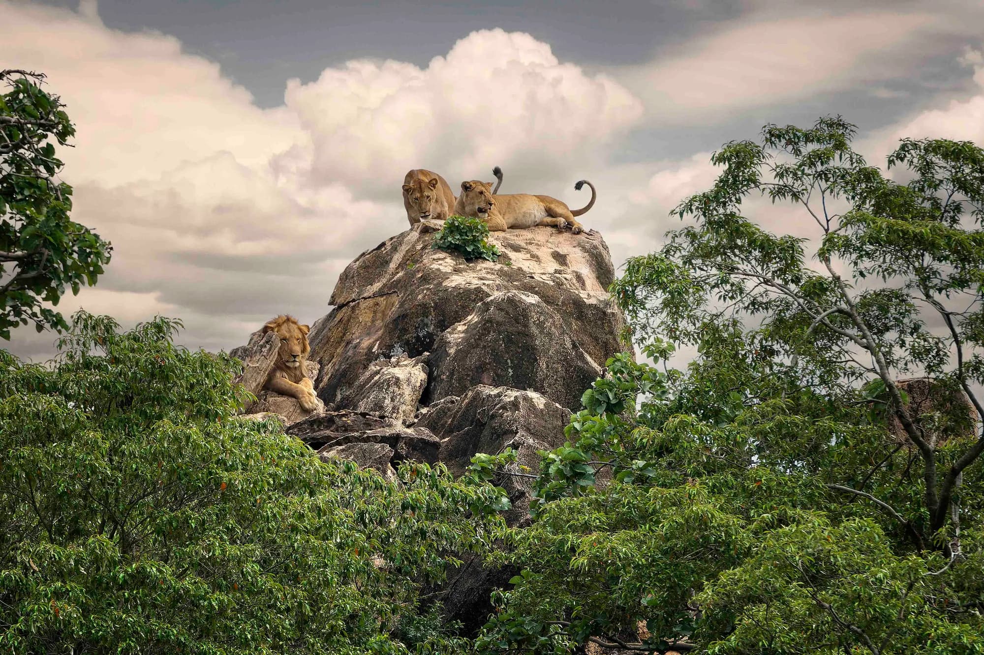
- Where to look: buffalo in the swamps along the valley floor; giraffe on the drier slopes above; and scan the rock outcrops for lions.
- Short nature walks around Apoka Rest Camp for zebra, hartebeest and reedbuck.
- Longer walks through the open grasslands of East Kakine for giraffe, buffalo, elephant and perhaps distant lions.
- The 15 km Rionomoe Trail on the southern side of the Narus Valley, which can be walked in part or whole. All walks require a ranger guide.
The vertical structure is the thing to carry into the vehicle
UWA's three clauses are a layered map of one valley, not a list of animals. Floor: swamp, buffalo, water. Slopes: drier, giraffe. Outcrops: rock, lions. On a drive that means your eye should be moving between three distinct heights rather than sweeping a horizon, and it means a stop at an outcrop is a different activity from a stop at a pool. Parties that treat the Narus as one undifferentiated plain see less of it than parties that treat it as three.
The newly created loops are the ones to take a ranger for
The brochure dates from 2018 and already describes those loops as "newly created". Eight years on we cannot say what state they are in, how they are marked, or whether they are still driven. What we can say is that the off-track driving fine is USD 150 per person in the vehicle and is charged to the driver, and that the published cost of a UWA ranger for the day is USD 20. If you intend to leave the three named circuits, the arithmetic has already been done for you on the permits page.
Uganda Wildlife Authority — Kidepo Valley National Park brochure, 2018
UWA's own two-page park brochure, linked from the download button on its Kidepo page as KVNP PARK BROCHURE and hosted on ugandawildlife.org. The file's internal creation date is 20 June 2018 and it is still the brochure UWA publishes. Downloaded (9.8 MB) and read on 14 October 2026. It is the only UWA document that explains the difference between the Narus and Kidepo valleys, names the game circuits, the campsites, the viewpoints and the trail, gives the two rainfall figures, gives the three road distances, describes the rest camp's bed stock, and names the species for which Kidepo is the only Ugandan refuge. It disagrees with UWA's own park page on the mammal count and on the distance from Kampala, and both figures are published here.
https://ugandawildlife.org/wp-content/uploads/2024/05/KVNP-2018-4.pdfUganda Wildlife Authority — Conservation Tariff 2024–2026
Downloaded and read page by page on 14 October 2026. Fifteen physical pages numbering themselves 1–24: entrance categories, vehicle and aircraft entry, guided and self game drives, walks, mountain activities, camping, research fees, fines, and a per-park fees summary. Kidepo appears in six separate places in it — the Category A entrance band, the guided game drive table, the self game drive table, the lower nature-walk band, the mountain activities table and its own summary on document page 21 — and those six places do not always agree. The tariff is printed "subject to change without prior notice". Its cover period, July 2024 to June 2026, expired on 30 June 2026 and UWA has published no successor: checked again on 14 October 2026, this is still the only tariff linked from ugandawildlife.org.
https://ugandawildlife.org/wp-content/uploads/2024/03/UWA-Conservation-Tariff-July-2024-June-2026.pdfThe Kidepo Valley drive — thirty kilometres for scenery, not for game
UWA is refreshingly direct about what the Kidepo Valley drive is and is not. Compared to the Narus, it says, the dry Kidepo Valley is short on big game but massive on scenery, and its vast scale more than justifies the thirty-kilometre drive from Apoka. That is a tourism authority telling you in its own brochure that you will not see much. Believe it, and go for the right reason.
The Kidepo Valley drive, point by point from Apoka
| Point | Distance | What UWA says is there |
|---|---|---|
| Apoka | 0 km | Headquarters, rest camp, airstrip, the start of everything |
| Lokimorigen | On the Narus–Kidepo watershed | A spectacular view towards the looming 2,975 m Jebel Lotuke in South Sudan |
| Kidepo River crossing | 30 km from Apoka | Descend and walk on the dry, sandy riverbed |
| The plains beyond the river | — | Mammals are rare; ostriches and secretary birds are often seen |
| Kanangorok Hot Springs | 11 km beyond the river | A modest cluster of small hot pools on the South Sudan border. A ranger guide escort is required |
Every figure and every description here is UWA's own wording from the Kidepo brochure. Note the word "modest" against the hot springs — it is UWA's, not ours. Kanangorok is a destination because of where it is, not because of what it is: a cluster of small pools at an international border, forty-one kilometres from the headquarters, in a valley the same document says is empty of mammals.
What the drive actually buys
A full day, roughly eighty kilometres of driving there and back on the hot springs run, a dry riverbed you can walk on, the only part of Uganda from which you can look at a 2,975-metre South Sudanese mountain, and an international border. It does not buy game. If you have three days at Kidepo, this is a good second or third day and a poor first one — the Narus pools are what you came for and they are twenty minutes from your bed. If you have two days, we would spend both in the Narus and skip it, and say so plainly rather than pretend the choice is free.
Uganda Wildlife Authority — Kidepo Valley National Park brochure, 2018
UWA's own two-page park brochure, linked from the download button on its Kidepo page as KVNP PARK BROCHURE and hosted on ugandawildlife.org. The file's internal creation date is 20 June 2018 and it is still the brochure UWA publishes. Downloaded (9.8 MB) and read on 14 October 2026. It is the only UWA document that explains the difference between the Narus and Kidepo valleys, names the game circuits, the campsites, the viewpoints and the trail, gives the two rainfall figures, gives the three road distances, describes the rest camp's bed stock, and names the species for which Kidepo is the only Ugandan refuge. It disagrees with UWA's own park page on the mammal count and on the distance from Kampala, and both figures are published here.
https://ugandawildlife.org/wp-content/uploads/2024/05/KVNP-2018-4.pdfApoka — headquarters, airstrip, rest camp and the reason the pick-up fee exists
Apoka is not a zone so much as the single point everything in Kidepo is measured from. UWA's park page puts it at the heart of the park; the brochure puts the park's wildlife, tourism activities and infrastructure in the southern Narus around it. Four separate things sit there.
- Park headquarters and the ranger guide base — UWA says experienced ranger guides are available at Apoka to help locate and identify birdlife across the park's habitats.
- The airstrip, which the tariff prices a UGX 50,000 pick-up from.
- Apoka Rest Camp — UWA's own hostel of twenty-one twin-bed bandas, fourteen self-contained, plus a four-bedroom self-catering guesthouse. A binocular viewpoint is installed here.
- Apoka Safari Lodge, which UWA describes as offering upmarket accommodation in luxurious cottages. It is a private operation; UWA publishes no rate for it.
Everything in this park is a radius from one point
The Narus circuits are minutes away. The Kidepo River crossing is thirty kilometres. Kanangorok is forty-one. Mount Morungule rises from the plains to the north east of Apoka. The Rionomoe Trail runs along the southern side of the same valley. There is no second hub, no northern gate camp, no alternative base — which is why a flight that lands you here with no vehicle leaves you genuinely stuck, and why UWA prices being collected. Compare Queen Elizabeth, where Mweya, Ishasha and Kyambura are three separate bases two hours apart and a bad choice of one is recoverable. At Kidepo there is only the one choice, and the park is easier to plan for it.
Uganda Wildlife Authority — Kidepo Valley National Park brochure, 2018
UWA's own two-page park brochure, linked from the download button on its Kidepo page as KVNP PARK BROCHURE and hosted on ugandawildlife.org. The file's internal creation date is 20 June 2018 and it is still the brochure UWA publishes. Downloaded (9.8 MB) and read on 14 October 2026. It is the only UWA document that explains the difference between the Narus and Kidepo valleys, names the game circuits, the campsites, the viewpoints and the trail, gives the two rainfall figures, gives the three road distances, describes the rest camp's bed stock, and names the species for which Kidepo is the only Ugandan refuge. It disagrees with UWA's own park page on the mammal count and on the distance from Kampala, and both figures are published here.
https://ugandawildlife.org/wp-content/uploads/2024/05/KVNP-2018-4.pdfUganda Wildlife Authority — Kidepo Valley National Park
UWA's own Kidepo park page, read 14 October 2026. The source here for the park size and altitude band, the 1962 gazettement, the distance from Kampala, the five-kilometre distance to the Kenyan border, the mammal and bird counts, the buffalo, elephant and giraffe figures, the named gates on each road route, the ten-hour drive time, and UWA's own wording on Karamoja.
https://ugandawildlife.org/national-parks/kidepo-valley-national-park/Uganda Wildlife Authority — Conservation Tariff 2024–2026
Downloaded and read page by page on 14 October 2026. Fifteen physical pages numbering themselves 1–24: entrance categories, vehicle and aircraft entry, guided and self game drives, walks, mountain activities, camping, research fees, fines, and a per-park fees summary. Kidepo appears in six separate places in it — the Category A entrance band, the guided game drive table, the self game drive table, the lower nature-walk band, the mountain activities table and its own summary on document page 21 — and those six places do not always agree. The tariff is printed "subject to change without prior notice". Its cover period, July 2024 to June 2026, expired on 30 June 2026 and UWA has published no successor: checked again on 14 October 2026, this is still the only tariff linked from ugandawildlife.org.
https://ugandawildlife.org/wp-content/uploads/2024/03/UWA-Conservation-Tariff-July-2024-June-2026.pdfThe mountains, which are the boundary on every side
Kidepo runs from 914 to 2,750 metres inside its own boundary, and UWA describes a landscape of grasslands roamed by big game extending towards rugged mountains in all points of the compass. Four ranges are named across its two documents, and they are the reason the park reads as a bowl rather than a plain.
The named high ground, and where UWA places it
| Feature | Height | Where UWA places it | Can you go? |
|---|---|---|---|
| Mount Morungule | 2,570 m | Rises from the plains to the north east of Apoka; the Ik live on it, on the Kenyan border | Yes — on foot with a ranger guide escort |
| Napore-Nyungea range | Not given | Visible in the 360-degree panorama from Kakine Campsite | Not stated |
| Mount Lomej | Not given | Brochure: in South Sudan. Tariff: a hike labelled KVNP | A priced hike at USD 40, plus entrance |
| Jebel Lotuke | 2,975 m | South Sudan, seen from the Lokimorigen watershed | No — viewed only |
| Lonyili | Not given | Not described anywhere in UWA's Kidepo material | A priced hike at USD 50 a day, entrance included |
The park's own altitude ceiling of 2,750 m is from UWA's park page. Note that Mount Morungule at 2,570 m sits below that ceiling, so the park's highest ground is somewhere UWA does not name. Jebel Lotuke at 2,975 m is outside Uganda entirely and is the highest thing in the view.
The sand rivers come off these mountains, which closes the loop
UWA's sentence is that the seasonal sand rivers fill, briefly, after rainstorms in the Morungule mountains. So the range north east of Apoka is the catchment, the valleys are the drains, and the Narus pools are what is left when the drain runs dry. The mountains are not scenery with a separate explanation; they are the first half of the water story the rest of this page is about.
Uganda Wildlife Authority — Kidepo Valley National Park brochure, 2018
UWA's own two-page park brochure, linked from the download button on its Kidepo page as KVNP PARK BROCHURE and hosted on ugandawildlife.org. The file's internal creation date is 20 June 2018 and it is still the brochure UWA publishes. Downloaded (9.8 MB) and read on 14 October 2026. It is the only UWA document that explains the difference between the Narus and Kidepo valleys, names the game circuits, the campsites, the viewpoints and the trail, gives the two rainfall figures, gives the three road distances, describes the rest camp's bed stock, and names the species for which Kidepo is the only Ugandan refuge. It disagrees with UWA's own park page on the mammal count and on the distance from Kampala, and both figures are published here.
https://ugandawildlife.org/wp-content/uploads/2024/05/KVNP-2018-4.pdfUganda Wildlife Authority — Kidepo Valley National Park
UWA's own Kidepo park page, read 14 October 2026. The source here for the park size and altitude band, the 1962 gazettement, the distance from Kampala, the five-kilometre distance to the Kenyan border, the mammal and bird counts, the buffalo, elephant and giraffe figures, the named gates on each road route, the ten-hour drive time, and UWA's own wording on Karamoja.
https://ugandawildlife.org/national-parks/kidepo-valley-national-park/Uganda Wildlife Authority — Conservation Tariff 2024–2026
Downloaded and read page by page on 14 October 2026. Fifteen physical pages numbering themselves 1–24: entrance categories, vehicle and aircraft entry, guided and self game drives, walks, mountain activities, camping, research fees, fines, and a per-park fees summary. Kidepo appears in six separate places in it — the Category A entrance band, the guided game drive table, the self game drive table, the lower nature-walk band, the mountain activities table and its own summary on document page 21 — and those six places do not always agree. The tariff is printed "subject to change without prior notice". Its cover period, July 2024 to June 2026, expired on 30 June 2026 and UWA has published no successor: checked again on 14 October 2026, this is still the only tariff linked from ugandawildlife.org.
https://ugandawildlife.org/wp-content/uploads/2024/03/UWA-Conservation-Tariff-July-2024-June-2026.pdfThe two gates, and what each road arrives at
Kidepo's gates are not zone entrances the way an Indian core zone gate is — there is one park and one circuit. They matter because they are on opposite sides of the park and they are the end of two completely different journeys.
The gates UWA names
| Gate | Reached from | UWA's description of the route |
|---|---|---|
| Lokumoit | The Gulu road | The most direct route; about 10 hours; can be broken at Ziwa Rhino Sanctuary, Gulu or Kitgum |
| Nataba | Through Karamoja | Two longer routes, which UWA describes as passing through the remote Karamoja subregion |
Both gate names are from UWA's Kidepo page, read 14 October 2026. Gate hours are not park-specific: the tariff's park rules page states that park gates open between 7am and 7pm, and sets a speed limit of 40 km/h, which is 25 mph. UWA publishes no distance from either gate to Apoka and we do not publish one.
The gate hours are the hidden constraint on a ten-hour drive
Gates close at 7pm and UWA's own estimate for the Gulu route is about ten hours. Leave Kampala at 09:00 and you arrive at 19:00 with nothing in hand — and that assumes ten hours exactly, on a road UWA describes as surfaced only as far as Kitgum, with no allowance for fuel, food or a puncture. This is the arithmetic behind UWA's own suggestion that the trip be broken with an overnight at Ziwa, Gulu or Kitgum. It is not a comfort recommendation. It is the only way the timing reliably works.
Uganda Wildlife Authority — Kidepo Valley National Park
UWA's own Kidepo park page, read 14 October 2026. The source here for the park size and altitude band, the 1962 gazettement, the distance from Kampala, the five-kilometre distance to the Kenyan border, the mammal and bird counts, the buffalo, elephant and giraffe figures, the named gates on each road route, the ten-hour drive time, and UWA's own wording on Karamoja.
https://ugandawildlife.org/national-parks/kidepo-valley-national-park/Uganda Wildlife Authority — Conservation Tariff 2024–2026
Downloaded and read page by page on 14 October 2026. Fifteen physical pages numbering themselves 1–24: entrance categories, vehicle and aircraft entry, guided and self game drives, walks, mountain activities, camping, research fees, fines, and a per-park fees summary. Kidepo appears in six separate places in it — the Category A entrance band, the guided game drive table, the self game drive table, the lower nature-walk band, the mountain activities table and its own summary on document page 21 — and those six places do not always agree. The tariff is printed "subject to change without prior notice". Its cover period, July 2024 to June 2026, expired on 30 June 2026 and UWA has published no successor: checked again on 14 October 2026, this is still the only tariff linked from ugandawildlife.org.
https://ugandawildlife.org/wp-content/uploads/2024/03/UWA-Conservation-Tariff-July-2024-June-2026.pdfThe four management zones, and what the plan says about the gates
UWA's own general management plan for this park divides it into four zones, which is a different and more formal thing than the two valleys. They are the zones that govern what may be built and done where, and no travel page we are aware of has ever mentioned them.
The management zones, from UWA's Kidepo general management plan
| Zone | What it is for | What it contains |
|---|---|---|
| Tourism | Enjoyment and appreciation of the interior of the park | Both valleys, all tourism trails, the hot springs, campsites and picnic areas; Apoka village, Katurum gate, the Karukudo and Opotipot outposts and the Lokorimongin observation point |
| Wilderness | Protection of biophysical and cultural values, because of the sensitivity of the environment | Visitor access must be carefully managed; basic low-impact facilities only, subject to environmental impact assessment |
| Administrative | Park operations | Not described in detail in the plan |
| Collaborative management / resource use | Negotiated community use | Along the boundary; the plan treats it as the interface with the farming villages |
The plan's own section heading lists the four as Wilderness, Collaborative management, Tourism and Administrative, and its next paragraph lists them as Wilderness, Tourism, Administrative and Resource Use — the fourth zone is named two ways in consecutive sentences. The tourism zone along the southern boundary runs from Lonyil hill up to Nataba gate and is about six kilometres wide east to west at the Lokorimongin observation point. Permitted in the tourism zone: visitor use day and overnight, camping and accommodation, information and interpretative services, and fire management. Prohibited: killing wild animals, timber harvesting, unauthorised fires and resource harvesting.
There are three gates, or four, and one of them is in the wrong place
The management plan's tourism chapter says Kidepo has three entry gates, at Nataba, Katurum and Kalokudo, and that none is constructed to a standard design. Its community conservation chapter says there are four, adding Apoka. UWA's 2026 web page names neither Katurum nor Kalokudo and instead names Lokumoit on the Gulu route and Nataba on the Karamoja routes — and the management plan elsewhere writes the same gate as Lokomoit/Katurum, which is the reconciliation: one gate, two names, and the road to it runs Karenga to Lokomoit/Katurum to Karukudo. The plan also records that Katurum gate sits about two kilometres inside the park rather than on the boundary, which it says renders the gate ineffective at controlling vehicles using the boundary road towards South Sudan, and lists relocating the Katurum and Nataba gates as a management action. Expect gate signage and gate names not to match whatever you printed out.
And this is where the two hikes finally resolve
The management plan settles what the tariff and the brochure between them left ambiguous. Lonyili is a summit of 2,248 metres in the park's north-west, on the international boundary itself: the plan's legal boundary description commences at boundary pillar number 912 on the summit of Lonyili on the Uganda-Sudan border. Morungole, in the east, rises to 2,749 metres, and the valley floors run from 914 to 1,219 metres. The Lomej hills, meanwhile, are west of Apoka and inside the park — the plan places them there twice, in its account of the 2004-5 fires. So the brochure's Mount Lomej in South Sudan is a different and more distant feature from the Lomej hills the tariff sells a walk in, and the tariff's label of KVNP against Hiking in Lomej is correct. The plan also explains the brochure's silence on Lonyili: re-opening the road to Lonyil hill and marketing the hill for hiking is listed as a management action for year six of the plan, budgeted at UGX 60 million. UWA has been selling a USD 50 summit hike up a hill whose access road its own plan scheduled for re-opening.
UWA — Kidepo Valley National Park General Management Plan, Ministry of Tourism Wildlife and Antiquities / UWA Planning Unit
A 114-page government management plan, hosted on ugandawildlife.org, downloaded and read on 14 October 2026. Its file name and cover say 2012–2022 and its running header on every page says 2011–2021; the PDF's internal creation date is 17 July 2013. It is by a distance the most detailed document UWA has published on this park, and almost none of it has reached a travel page. It is the source here for the four management zones, the gate names and their problems, the summit heights of Lonyili and Morungole, the location of the airstrip, the 2008 Wildlife Conservation Society and Makerere University biodiversity survey figures, the 28 mammals found in no other Ugandan national park, the species the park has lost, and the cheetah population history. Where it disagrees with UWA's 2018 brochure or its 2026 web page, all figures are published.
https://ugandawildlife.org/wp-content/uploads/2022/01/Kidepo_Valley_-National_Park_GMP.pdfUganda Wildlife Authority — Kidepo Valley National Park
UWA's own Kidepo park page, read 14 October 2026. The source here for the park size and altitude band, the 1962 gazettement, the distance from Kampala, the five-kilometre distance to the Kenyan border, the mammal and bird counts, the buffalo, elephant and giraffe figures, the named gates on each road route, the ten-hour drive time, and UWA's own wording on Karamoja.
https://ugandawildlife.org/national-parks/kidepo-valley-national-park/Uganda Wildlife Authority — Conservation Tariff 2024–2026
Downloaded and read page by page on 14 October 2026. Fifteen physical pages numbering themselves 1–24: entrance categories, vehicle and aircraft entry, guided and self game drives, walks, mountain activities, camping, research fees, fines, and a per-park fees summary. Kidepo appears in six separate places in it — the Category A entrance band, the guided game drive table, the self game drive table, the lower nature-walk band, the mountain activities table and its own summary on document page 21 — and those six places do not always agree. The tariff is printed "subject to change without prior notice". Its cover period, July 2024 to June 2026, expired on 30 June 2026 and UWA has published no successor: checked again on 14 October 2026, this is still the only tariff linked from ugandawildlife.org.
https://ugandawildlife.org/wp-content/uploads/2024/03/UWA-Conservation-Tariff-July-2024-June-2026.pdf