
Kenya / Tsavo West / Zones — Tsavo West
Zones — Tsavo West
The Tsavo river cuts this park almost in half and the two halves get completely different amounts of attention. Almost every visitor sees the northern triangle; almost nobody goes south, where the park runs down to a lake shared with Tanzania.
The size, and two published areas that do not agree
Tsavo West is the smaller of the two Tsavos and it is still one of the largest parks on this site. How much smaller depends on which document you read, and two reputable ones give answers nearly two thousand square kilometres apart.
Published areas for Tsavo West, and what they are next to
| Figure | Source | What kind of claim |
|---|---|---|
| 9,065.0 sq km | World Database on Protected Areas, site 19564 | The WDPA reported-area field |
| 7,327.91 sq km | Key Biodiversity Areas Partnership, factsheet 6415 | The KBA site area for a site it names Tsavo West National Park |
| 11,747.0 sq km | WDPA site 752, for Tsavo East | The neighbour, for scale |
| 741 sq km | Chyulu Hills National Park, gazetted 1983 | The adjoining park, which is a separate fee |
The first two are both descriptions of Tsavo West and they differ by 1,737 square kilometres — an area larger than several whole parks on this site. We could not read what Kenya Wildlife Service itself prints, because kws.go.ke refused us on 28 September 2026. Both figures appear on these pages and neither is presented as settled. Where a ratio is needed below, the WDPA figure is used and is named.
A KBA boundary and a gazetted park boundary are not obliged to be the same thing, and that may be the whole explanation — but the KBA factsheet calls its site Tsavo West National Park rather than a subset of it, so we are not going to assert the explanation we would find convenient. What is not in doubt is the comparison that matters to a visitor: Tsavo West is roughly three-quarters the size of Tsavo East on the WDPA figures, and something over twenty times the size of Amboseli.
Why smaller is the selling point here
Tsavo East's pages argue that its scale is the reason it reads as empty and the reason a short trip fails there. Tsavo West inverts that. It is smaller, the features are clustered, and two nights in the northern sector is a genuinely complete trip rather than a sample of one. What you lose is the emptiness — you will meet other vehicles at Mzima — and what you gain is a park you can actually finish.
UNEP-WCMC, World Database on Protected Areas — Tsavo West, WDPA site 19564
Read 28 September 2026. Protected Planet gives Tsavo West a reported area of 9,065.0 square kilometres. Tsavo East, on site 752, was read the same day and is given as 11,747.0 square kilometres. Both are the WDPA's reported-area field and neither was readable from Kenya Wildlife Service itself, because kws.go.ke refused us on 28 September 2026.
https://www.protectedplanet.net/19564Key Biodiversity Areas Partnership — Tsavo West National Park, site factsheet 6415
Read 28 September 2026. The factsheet names the site Tsavo West National Park, in Kenya, and gives an area of 7,327.91 square kilometres — which does not agree with the World Database on Protected Areas. It qualifies under criterion B2, and the trigger and qualifying species listed include the Near Threatened Mirafra pulpa and Crex crex, alongside Loxodonta africana (EN) and Diceros bicornis (CR). The habitat description gives Acacia-Commiphora bushland in the northern sectors, rocky outcrops, the Chyulu Hills with their ash cones and lava flows, open grassy plains in the south, riverine woodland along the Tsavo river, and extensive beds of Typha with large permanent swamps at Lake Jipe. On threats it states that the park faces no major threats at present, while listing nomadic grazing, fire suppression, invasive species, mining, drought and storms, and roads, railways and flight paths as ongoing concerns.
https://www.keybiodiversityareas.org/en/site/factsheet/6415Wikipedia — Chyulu Hills
Read 28 September 2026, and flagged as an encyclopaedia rather than an authority. It gives the Chyulus as a 100-kilometre-long volcanic field running north-west to south-east, with volcanism beginning about 1.4 million years ago in the north and propagating south-east over time; Chyulu Hills National Park as 741 square kilometres, gazetted in 1983 and run by Kenya Wildlife Service; Leviathan Cave, also called the Kisula caves, as about 11 kilometres long and one of the longest caves in Africa; montane forest above roughly 1,800 metres with grassland and thicket below; and rainfall on the hills feeding the Tsavo and Galana rivers and Mzima Springs.
https://en.wikipedia.org/wiki/Chyulu_HillsThe northern sector, above the Tsavo river
There is no zone system, no gate allocation and no permitted route. What there is instead is a triangle in the north-west of the park — roughly between Mtito Andei gate, Mzima Springs and the Ngulia hills — that holds the tracks, the lodges, the named features and effectively all of the visitors. Everything sold as Tsavo West lives inside it.
The northern triangle, piece by piece
| Place | What it is | What it gives you |
|---|---|---|
| Mzima Springs | Four springs rising from the Chyulu aquifer, with a walking circuit and an underwater viewing chamber | The signature stop, and the only place you routinely leave the vehicle |
| Kilaguni | The long-established lodge area and airstrip on the Chyulu side | Waterhole viewing from a fixed point, and the best base for Mzima |
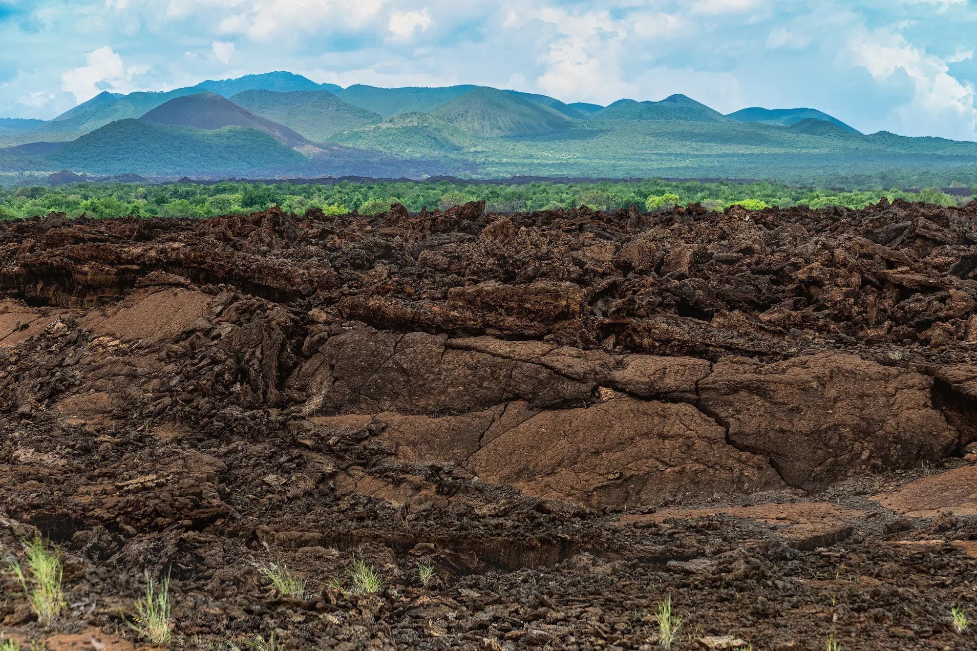
| The Shetani lava flow | A young black lava field beside the Chyulu gate road | The strangest landscape in either Tsavo, and a short walk on it |
| Chaimu crater | A black cinder cone you can climb | A half-hour walk and the view down over the lava country |
| The Roaring Rocks | An escarpment viewpoint above the plains | The wide view that explains the whole park's geography |
| Ngulia hills | The ridge above the old rhino sanctuary, and Ngulia Safari Lodge | Rhino country, raptors, and the November bird-ringing site |
| The Tsavo river | The park's dividing line, running east to the Galana | Permanent water, riverine woodland, and the boundary of the visited park |
Everything in this table can be worked from a single northern base in two or three days. That is the case for Tsavo West as a short trip and it is a real one.
The Key Biodiversity Areas factsheet describes this northern country as Acacia-Commiphora bushland with rocky outcrops, and the Chyulu Hills with their ash cones and lava flows. That is an accurate and slightly deflating description of what you will be driving through: thick, grey-green, thorny scrub broken by black rock. It is the reason the scenery is good and the reason the game viewing is hard, and those are the same fact.
Key Biodiversity Areas Partnership — Tsavo West National Park, site factsheet 6415
Read 28 September 2026. The factsheet names the site Tsavo West National Park, in Kenya, and gives an area of 7,327.91 square kilometres — which does not agree with the World Database on Protected Areas. It qualifies under criterion B2, and the trigger and qualifying species listed include the Near Threatened Mirafra pulpa and Crex crex, alongside Loxodonta africana (EN) and Diceros bicornis (CR). The habitat description gives Acacia-Commiphora bushland in the northern sectors, rocky outcrops, the Chyulu Hills with their ash cones and lava flows, open grassy plains in the south, riverine woodland along the Tsavo river, and extensive beds of Typha with large permanent swamps at Lake Jipe. On threats it states that the park faces no major threats at present, while listing nomadic grazing, fire suppression, invasive species, mining, drought and storms, and roads, railways and flight paths as ongoing concerns.
https://www.keybiodiversityareas.org/en/site/factsheet/6415Mzima Springs
Mzima is the reason a great many people come to Tsavo West and it is worth understanding what it actually is, because the mechanism is more remarkable than the stop. Rain falls on the Chyulu Hills, a hundred-kilometre volcanic field too porous to hold surface rivers. It sinks. Tsavo Trust says the water can remain subterranean for up to 25 years, and Wikipedia's account puts the emergence 50 kilometres from where the rain fell. It comes out here, filtered through lava, into a series of pools clear enough to see the bottom of.
How much water, according to whom
| Figure | Source | What it is actually measuring |
|---|---|---|
| 35,000 cubic metres a day | Mwaura et al. 2016, table 4 | The abstracted consumptive yield counted in an economic valuation, not the springs' discharge |
| 20,000 cubic metres a day | Wikipedia | What is piped to Voi, Mariakani and the South Coast |
| One-third of Mombasa's water since the 1950s | Big Life Foundation | The pipeline's share of a city supply, not a volume |
| Up to 80 per cent of Chyulu rainfall | Mwaura et al., citing previous studies | The proportion of the hills' rain that is discharged at Mzima rather than at the watershed's other springs |
Notice that none of these is a measurement of how much water the springs produce. Every figure we could source is an abstraction figure, a pipeline share or a catchment proportion. The widely repeated tourist figure is fifty million gallons a day, and we could not trace it to any measuring authority, so it does not appear on these pages as a fact.
The number you will be told, and why it is not here
Guides, brochures and a great many websites give Mzima's output as fifty million gallons a day, or the same figure converted into litres by somebody who did not notice the unit — which is how two-hundred-odd million litres and fifty million litres both circulate for the same spring. We tried to find the original measurement and could not. What we can source is the 35,000 cubic metres a day that Mwaura and colleagues put in their valuation table, which is a much smaller and quite different quantity. Publishing the big number without its origin would be the easiest thing on this page and the wrong thing.
The walking circuit is the point. It is the one place in either Tsavo where a visitor routinely leaves the vehicle and walks, on a marked path, alongside water with hippo and crocodile in it. Tsavo Trust confirms the underwater viewing chamber exists and that visitors can watch aquatic life from it. What the chamber shows on any given day is another matter, and the sightings page deals with it honestly rather than promising you hippos through glass.
Tsavo Trust — Mzima Springs: clear waters and the impact of hippos
Read 28 September 2026. The Trust describes the Chyulu Hills as a mountain range constituting a 100-kilometre-long volcanic field, states that the water can remain subterranean for up to 25 years before emerging at Mzima, and confirms that the springs carry an underwater viewing tank from which visitors can watch aquatic life. It sets out the role of hippo dung in the food chain and the effect of the 2009 drought on the resident animals. It publishes no daily output figure, no dimensions for the viewing chamber and no statement of its current condition.
https://tsavotrust.org/mzima-springs-clear-waters-and-the-impact-of-hippos/Wikipedia — Mzima Springs
Read 28 September 2026, and flagged as an encyclopaedia rather than an authority because no departmental figure was reachable. It gives the source of the springs as a natural reservoir under the Chyulu Hills to the north, rainwater percolating through volcanic rock and spending up to 25 years underground before emerging 50 kilometres away at Mzima, and a supply of 20,000 cubic metres a day to Voi, Mariakani and the South Coast. On the hippos it gives 70 animals in 2003 and only five remaining in September 2009, after the drought. It describes the stream running through a series of pools and rapids before disappearing two kilometres downstream. It does not describe the underwater viewing chamber or its condition.
https://en.wikipedia.org/wiki/Mzima_SpringsMwaura, Kiringe, Warinwa and Wandera — Estimation of the economic value for the consumptive water use ecosystem service benefits of the Chyulu Hills watershed, Kenya; International Journal of Agriculture, Forestry and Fisheries 2016, 4(4): 36-48
Read 28 September 2026 from the copy the African Wildlife Foundation hosts. Table 4, covering the southern zone of the watershed, gives Mzima Springs an estimated water yield of 35,000 cubic metres per day and 12,775,000 cubic metres per year, in a column headed m3 per day. That is the abstracted consumptive yield counted in the study's valuation, not a measurement of the springs' total discharge, and the two should not be confused. The paper also states that previous studies have estimated that up to 80 per cent of the rainfall on the Chyulu Hills is intercepted by the forest ecosystem and later discharged at Mzima Springs, with the remaining 20 per cent feeding the watershed's other springs, and that Mzima, besides serving the city of Mombasa, is a key water source for the Tsavo river.
https://www.awf.org/sites/default/files/2024-09/Mwaura%20et%20al_IntJofAgFF_2016.%20Estimation%20of%20the%20economic%20value%20for%20the%20consumptive%20water%20use%20ecosystem%20service%20benefits%20of%20the%20Chyulu%20Hills%20watershed%2C%20Kenya.pdfBig Life Foundation — Hidden water of the Chyulu Hills, 22 March 2022
Read 28 September 2026. Big Life gives the Chyulu Hills aquifer as containing 158,503,231,415 gallons of water, and states that the pipeline from the hills has supplied one-third of Mombasa's water since the 1950s. It names Mzima Springs as a destination known for its hippos and crocodiles but publishes no discharge figure for it.
https://biglife.org/program-updates/big-life-news/hidden-water-of-the-chyulu-hillsNgulia, and the sanctuary that stopped being a sanctuary
This is the part of Tsavo West most likely to be described to you wrongly, because the description was right until recently. The Ngulia Rhino Sanctuary was established at the foot of the Ngulia hills as a fenced enclosure for eastern black rhino. Save the Rhino International gives it as 92 square kilometres and states that for many years it exceeded its ecological carrying capacity, which limited breeding and survival. It was not the open park: it had a fence, an entrance, and rules of its own.
Before and after 9 December 2025
| The Ngulia Rhino Sanctuary | The Tsavo West Rhino Sanctuary | |
|---|---|---|
| Area | 92 sq km | More than 3,200 sq km |
| Rhino | 150 black rhino at the point of merger | Founder population of 200, with 50 from the Intensive Protection Zone |
| Fencing | Fenced enclosure within the park | More than 250 km of upgraded fencing |
| Share of Tsavo West | About 1 per cent on the WDPA area | About 35 per cent on the WDPA area |
| What a sighting is | Driving into an enclosure | Finding a wild animal in bushland |
Areas and rhino numbers are Save the Rhino International's and The Star's; the share-of-park arithmetic is ours, using the WDPA figure of 9,065 square kilometres, and it would be about 44 per cent on the Key Biodiversity Areas figure instead. The two source areas for the park are set out at the top of this page.
The Star's report of the launch on 9 December 2025 adds the machinery behind it: more than 250 kilometres of upgraded fencing, 90 rhinos immobilised and 89 fitted with tracking devices, 40 new ranger houses and operational bases, more than 300 security personnel, and USD 4.7 million invested in protection systems. The national targets attached to it are 1,450 black rhinos by 2030 and 2,000 rhinos by 2037, with the annual black rhino growth rate to rise from 5 per cent to 8. Kenya's rhino total is given as about 2,100 — 1,060 black, 1,040 southern white and the world's last two northern white — with Kenya holding 78 per cent of the global eastern black rhino population.
What we could not verify, and it is the thing you most need
Whether a general visitor may now enter the Tsavo West Rhino Sanctuary, on what terms, through which gate, at what hours and for what fee. That is exactly the sort of fact that must come from the department and nowhere else, and kws.go.ke refused us on 28 September 2026 — the fee PDF, the press release page and the PDF of the press release all returned a TLS certificate that could not be verified. The Star's report carries nothing about visitor access. Treat the sanctuary's access rules as unknown to you until KWS or a gate tells you otherwise, and do not let an itinerary written before December 2025 make the promise for them.
Save the Rhino International — Groundbreaking expansion of Tsavo West Rhino Sanctuary in Kenya
Read 28 September 2026. Save the Rhino International is a partner in the Kenya Rhino Range Expansion programme, which is why its account is used here rather than an operator's. It gives the opening date as 9 December 2025; the former Ngulia Rhino Sanctuary as 92 square kilometres; the new Tsavo West Rhino Sanctuary as 3,200 square kilometres; 150 black rhinos from Ngulia merging with 50 from the Tsavo West Intensive Protection Zone to form a founder population of 200, described as the largest single black rhino population in Kenya; and states that for many years the 92 square kilometre Ngulia sanctuary exceeded its ecological carrying capacity, which limited breeding and survival.
https://www.savetherhino.org/africa/pioneering-tsavo-west-rhino-sanctuary-opens-in-kenya/The Star (Kenya) — Ruto launches world's largest rhino sanctuary in Tsavo West, 9 December 2025
Read 28 September 2026. A Kenyan newspaper report of the launch, used because Kenya Wildlife Service's own press release on the same event was unreadable to us — kws.go.ke returned a TLS certificate that could not be verified on 28 September 2026, for both the HTML release and the PDF of it. The report gives the sanctuary as more than 3,200 square kilometres with more than 250 kilometres of upgraded fencing; 90 rhinos immobilised and 89 fitted with tracking devices; 40 new ranger houses and operational bases and more than 300 security personnel; USD 4.7 million, given as Sh606 million, invested in protection systems; national targets of 1,450 black rhinos by 2030 and 2,000 rhinos by 2037, with the annual black rhino growth rate to rise from 5 to 8 per cent; and projections of more than 18,000 jobs and USD 45 million, given as Sh5.8 billion, in tourism and conservancy revenue by 2030. On national rhino numbers it gives about 2,100 in total — 1,060 black, 1,040 southern white and the world's last two northern white — and states that Kenya holds 78 per cent of the global eastern black rhino population. It carries nothing about visitor access to the sanctuary.
https://www.the-star.co.ke/news/2025-12-09-ruto-launches-worlds-largest-rhino-sanctuary-in-tsavo-westUNEP-WCMC, World Database on Protected Areas — Tsavo West, WDPA site 19564
Read 28 September 2026. Protected Planet gives Tsavo West a reported area of 9,065.0 square kilometres. Tsavo East, on site 752, was read the same day and is given as 11,747.0 square kilometres. Both are the WDPA's reported-area field and neither was readable from Kenya Wildlife Service itself, because kws.go.ke refused us on 28 September 2026.
https://www.protectedplanet.net/19564South of the Tsavo river — Maktau, Ziwani and Lake Jipe
Below the Tsavo river the park changes character and loses almost all of its visitors. The Key Biodiversity Areas factsheet describes open grassy plains in the south, against the thick bushland of the north, and gives Lake Jipe extensive beds of Typha with large permanent swamps. It is more open, more remote, and it ends at an international border.
The southern sector
| Place | What it is | Why you would go |
|---|---|---|
| Lake Jipe | A shallow freshwater lake on the Kenya-Tanzania border, the park holding its northern shore | Water birds, elephant coming down to drink, the Pare mountains across the water |
| The Maktau side | The park's southern approach from the Voi-Taveta road | The quiet way in, and the open plains |
| Ziwani | The south-western corner, on the Tsavo river above Jipe | A separate approach and a very lightly used part of the park |
| The Tanzanian border | Mkomazi lies opposite | Context rather than a destination: this is a two-country ecosystem |
Nothing in this table is reachable as an afternoon from a northern lodge. The southern sector is a base decision or a long transit, and that is why almost nobody does it.
Jipe is the one that earns the drive. The KBA factsheet's trigger species for the whole park include the Near Threatened Mirafra pulpa and Crex crex — the corn crake, a migrant — and the lake's Typha beds and permanent swamp are the habitat that makes Tsavo West a bird site rather than merely a park with birds in it. It is also where you see the park's geography plainly: open water, a mountain wall in another country, and elephants walking down to drink across a plain.
The honest caution
We hold no current KWS statement about access, road condition or security in the southern sector, and a park boundary that is also a national border is not somewhere to improvise. Ask at the gate you enter by, take a guide who has been recently rather than one who has heard about it, and do not plan Jipe as a day trip from Kilaguni.
Key Biodiversity Areas Partnership — Tsavo West National Park, site factsheet 6415
Read 28 September 2026. The factsheet names the site Tsavo West National Park, in Kenya, and gives an area of 7,327.91 square kilometres — which does not agree with the World Database on Protected Areas. It qualifies under criterion B2, and the trigger and qualifying species listed include the Near Threatened Mirafra pulpa and Crex crex, alongside Loxodonta africana (EN) and Diceros bicornis (CR). The habitat description gives Acacia-Commiphora bushland in the northern sectors, rocky outcrops, the Chyulu Hills with their ash cones and lava flows, open grassy plains in the south, riverine woodland along the Tsavo river, and extensive beds of Typha with large permanent swamps at Lake Jipe. On threats it states that the park faces no major threats at present, while listing nomadic grazing, fire suppression, invasive species, mining, drought and storms, and roads, railways and flight paths as ongoing concerns.
https://www.keybiodiversityareas.org/en/site/factsheet/6415The volcanic country, which is why the scenery beats Tsavo East's
Tsavo East is flat red thorn country under a big sky, with one great landscape feature along its western edge. Tsavo West is broken, hilly, black-rocked and green, and the reason is volcanic. The Chyulu Hills, which Wikipedia gives as a hundred-kilometre volcanic field with volcanism beginning about 1.4 million years ago in the north and moving south-east, sit along the park's north-western flank and are a separate national park of 741 square kilometres gazetted in 1983.
- The Shetani lava flow. Tsavo Trust gives it as 8 kilometres long, 1.6 wide and 5 metres deep, formed 240 years ago, with shetani the Swahili for devil. Two hundred and forty years is nothing: this is a landscape younger than most of the buildings in a European city, and it looks it.
- Chaimu crater, a black cinder cone with a walking route up it, and one of the few places in the park you are permitted to be out of the vehicle.
- The Roaring Rocks, an escarpment viewpoint from which the geography of the whole park becomes legible in one look.
- Leviathan Cave in the Chyulus, given as about 11 kilometres long and one of the longest caves in Africa, which is in the adjoining park rather than this one.
- The Chyulu forest, montane above roughly 1,800 metres, which is the sponge that produces Mzima Springs.
- The Tsavo river, whose riverine woodland the KBA factsheet names as its own habitat type within the park.
The one-sentence comparison
If you want to look at Kenya, come to Tsavo West. If you want to count animals, go to Tsavo East, or better, to Amboseli or the Mara. Nobody who has done both parks disagrees about which is more beautiful, and almost nobody who has done both disagrees about which produced more sightings.
Tsavo Trust — Four of the Tsavo Conservation Area's most spectacular topographical phenomena
Read 28 September 2026. The Shetani lava flow is given as 8 kilometres long, 1.6 wide and 5 metres deep, formed 240 years ago, with shetani given as the Swahili for devil. Mzima Springs is given as around 48 kilometres from Mtito Andei, fed from an underground reservoir beneath the Chyulu Hills, with the water running two kilometres downstream before going underground again. The Yatta Plateau, which is Tsavo East's, is given as a ridge running 290 kilometres from Ol Doinyo Sabuk and is described as the world's longest lava flow. Lugard Falls, also Tsavo East's, is the Galana's passage over volcanic rock worn into flattened ledges.
https://tsavotrust.org/four-of-the-tsavo-conservation-areas-most-spectacular-topographical-phenomena/Wikipedia — Chyulu Hills
Read 28 September 2026, and flagged as an encyclopaedia rather than an authority. It gives the Chyulus as a 100-kilometre-long volcanic field running north-west to south-east, with volcanism beginning about 1.4 million years ago in the north and propagating south-east over time; Chyulu Hills National Park as 741 square kilometres, gazetted in 1983 and run by Kenya Wildlife Service; Leviathan Cave, also called the Kisula caves, as about 11 kilometres long and one of the longest caves in Africa; montane forest above roughly 1,800 metres with grassland and thicket below; and rainfall on the hills feeding the Tsavo and Galana rivers and Mzima Springs.
https://en.wikipedia.org/wiki/Chyulu_HillsKey Biodiversity Areas Partnership — Tsavo West National Park, site factsheet 6415
Read 28 September 2026. The factsheet names the site Tsavo West National Park, in Kenya, and gives an area of 7,327.91 square kilometres — which does not agree with the World Database on Protected Areas. It qualifies under criterion B2, and the trigger and qualifying species listed include the Near Threatened Mirafra pulpa and Crex crex, alongside Loxodonta africana (EN) and Diceros bicornis (CR). The habitat description gives Acacia-Commiphora bushland in the northern sectors, rocky outcrops, the Chyulu Hills with their ash cones and lava flows, open grassy plains in the south, riverine woodland along the Tsavo river, and extensive beds of Typha with large permanent swamps at Lake Jipe. On threats it states that the park faces no major threats at present, while listing nomadic grazing, fire suppression, invasive species, mining, drought and storms, and roads, railways and flight paths as ongoing concerns.
https://www.keybiodiversityareas.org/en/site/factsheet/6415The rules, and where you may leave the vehicle
- Stay in the vehicle, except at Mzima Springs, Chaimu crater, the Roaring Rocks viewpoint, the Shetani flow and designated picnic sites.
- At Mzima in particular, the walk is a marked circuit alongside water containing hippo and crocodile. Stay on the path, keep between the water and nothing, and do not put yourself between a hippo and the pool.
- No off-road driving. In lava country this is also self-preservation: the rock will take a sump off.
- No night driving. The park runs to gate hours and does not operate after dark.
- No walking safaris inside the national park beyond the designated sites above.
- The rhino sanctuary is not the open park. Whatever its rules are now, they are its own and they are not yours to assume.
- Carry water and know your fuel range, particularly if you are going south.
The Mzima exception is the one that needs saying twice, because the walk is so civilised — a path, a handrail in places, a viewing chamber at the end — that people forget what is in the water. Wikipedia records 70 hippos at Mzima in 2003 and five remaining in September 2009 after the drought. Numbers move; the animals are wild and the path is not a zoo walkway.
Wikipedia — Mzima Springs
Read 28 September 2026, and flagged as an encyclopaedia rather than an authority because no departmental figure was reachable. It gives the source of the springs as a natural reservoir under the Chyulu Hills to the north, rainwater percolating through volcanic rock and spending up to 25 years underground before emerging 50 kilometres away at Mzima, and a supply of 20,000 cubic metres a day to Voi, Mariakani and the South Coast. On the hippos it gives 70 animals in 2003 and only five remaining in September 2009, after the drought. It describes the stream running through a series of pools and rapids before disappearing two kilometres downstream. It does not describe the underwater viewing chamber or its condition.
https://en.wikipedia.org/wiki/Mzima_Springs